Fantastic, detailed imagery celebrating Mars Reconnaissance's 10 years of operation.
Mars Reconnaissance Orbiter movie link
Showing posts with label mars reconnaissance. Show all posts
Showing posts with label mars reconnaissance. Show all posts
Monday, 19 December 2016

Friday, 1 January 2016
NASA Confirms Evidence That Liquid Water Flows on Today's Mars (NASA - Oct 2015 Announcement)

New findings from NASA's Mars Reconnaissance Orbiter (MRO) provide the strongest evidence yet that liquid water flows intermittently on present-day Mars.
Using an imaging spectrometer on MRO, researchers detected signatures of hydrated minerals on slopes where mysterious streaks are seen on the Red Planet. These darkish streaks appear to ebb and flow over time. They darken and appear to flow down steep slopes during warm seasons, and then fade in cooler seasons. They appear in several locations on Mars when temperatures are above minus 10 degrees Fahrenheit (minus 23 Celsius), and disappear at colder times.
"Our quest on Mars has been to 'follow the water,' in our search for life in the universe, and now we have convincing science that validates what we've long suspected," said John Grunsfeld, astronaut and associate administrator of NASA's Science Mission Directorate in Washington. "This is a significant development, as it appears to confirm that water -- albeit briny -- is flowing today on the surface of Mars."
These downhill flows, known as recurring slope lineae (RSL), often have been described as possibly related to liquid water. The new findings of hydrated salts on the slopes point to what that relationship may be to these dark features. The hydrated salts would lower the freezing point of a liquid brine, just as salt on roads here on Earth causes ice and snow to melt more rapidly. Scientists say it's likely a shallow subsurface flow, with enough water wicking to the surface to explain the darkening.
"We found the hydrated salts only when the seasonal features were widest, which suggests that either the dark streaks themselves or a process that forms them is the source of the hydration. In either case, the detection of hydrated salts on these slopes means that water plays a vital role in the formation of these streaks," said Lujendra Ojha of the Georgia Institute of Technology (Georgia Tech) in Atlanta, lead author of a report on these findings published Sept. 28 by Nature Geoscience.
Ojha first noticed these puzzling features as a University of Arizona undergraduate student in 2010, using images from the MRO's High Resolution Imaging Science Experiment (HiRISE). HiRISE observations now have documented RSL at dozens of sites on Mars. The new study pairs HiRISE observations with mineral mapping by MRO's Compact Reconnaissance Imaging Spectrometer for Mars (CRISM).
The spectrometer observations show signatures of hydrated salts at multiple RSL locations, but only when the dark features were relatively wide. When the researchers looked at the same locations and RSL weren't as extensive, they detected no hydrated salt.
Ojha and his co-authors interpret the spectral signatures as caused by hydrated minerals called perchlorates. The hydrated salts most consistent with the chemical signatures are likely a mixture of magnesium perchlorate, magnesium chlorate and sodium perchlorate. Some perchlorates have been shown to keep liquids from freezing even when conditions are as cold as minus 94 degrees Fahrenheit (minus 70 Celsius). On Earth, naturally produced perchlorates are concentrated in deserts, and some types of perchlorates can be used as rocket propellant.
Perchlorates have previously been seen on Mars. NASA's Phoenix lander and Curiosity rover both found them in the planet's soil, and some scientists believe that the Viking missions in the 1970s measured signatures of these salts. However, this study of RSL detected perchlorates, now in hydrated form, in different areas than those explored by the landers. This also is the first time perchlorates have been identified from orbit.
MRO has been examining Mars since 2006 with its six science instruments.
"The ability of MRO to observe for multiple Mars years with a payload able to see the fine detail of these features has enabled findings such as these: first identifying the puzzling seasonal streaks and now making a big step towards explaining what they are," said Rich Zurek, MRO project scientist at NASA's Jet Propulsion Laboratory in Pasadena, California.
For Ojha, the new findings are more proof that the mysterious lines he first saw darkening Martian slopes five years ago are, indeed, present-day water.
"When most people talk about water on Mars, they're usually talking about ancient water or frozen water," he said. "Now we know there's more to the story. This is the first spectral detection that unambiguously supports our liquid water-formation hypotheses for RSL."
The discovery is the latest of many breakthroughs by NASA's Mars missions.
"It took multiple spacecraft over several years to solve this mystery, and now we know there is liquid water on the surface of this cold, desert planet," said Michael Meyer, lead scientist for NASA's Mars Exploration Program at the agency's headquarters in Washington. "It seems that the more we study Mars, the more we learn how life could be supported and where there are resources to support life in the future."
What Happened to Early Mars' Atmosphere? New Study Eliminates One Theory (NASA)
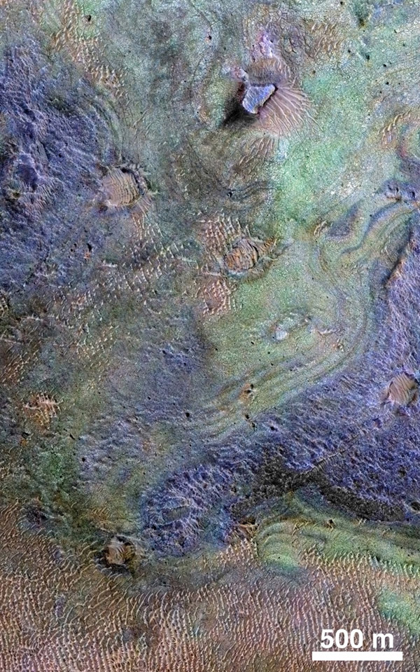
This view combines information from two instruments on a NASA Mars orbiter to map color-coded composition over the shape of the ground within the Nili Fossae plains region of Mars. Image credit: NASA/JPL-Caltech/JHUAPL/Univ. of Arizona› Full image and caption
Scientists may be closer to solving the mystery of how Mars changed from a world with surface water billions of years ago to the arid Red Planet of today.
A new analysis of the largest known deposit of carbonate minerals on Mars suggests that the original Martian atmosphere may have already lost most of its carbon dioxide by the era of valley network formation.
"The biggest carbonate deposit on Mars has, at most, twice as much carbon in it as the current Mars atmosphere," said Bethany Ehlmann of the California Institute of Technology and NASA Jet Propulsion Laboratory, both in Pasadena. "Even if you combined all known carbon reservoirs together, it is still nowhere near enough to sequester the thick atmosphere that has been proposed for the time when there were rivers flowing on the Martian surface."
Carbon dioxide makes up most of the Martian atmosphere. That gas can be pulled out of the air and sequestered or pulled into the ground by chemical reactions with rocks to form carbonate minerals. Years before the series of successful Mars missions, many scientists expected to find large Martian deposits of carbonates holding much of the carbon from the planet's original atmosphere. Instead, these missions have found low concentrations of carbonate distributed widely, and only a few concentrated deposits. By far the largest known carbonate-rich deposit on Mars covers an area at least the size of Delaware, and maybe as large as Arizona, in a region called Nili Fossae.
Christopher Edwards, a former Caltech researcher now with the U.S. Geological Survey in Flagstaff, Arizona, and Ehlmann reported the findings and analysis in a paper posted online by the journal Geology. Their estimate of how much carbon is locked into the Nili Fossae carbonate deposit uses observations from numerous Mars missions, including the Thermal Emission Spectrometer (TES) on NASA's Mars Global Surveyor orbiter, the mineral-mapping Compact Reconnaissance Imaging Spectrometer for Mars (CRISM) and two telescopic cameras on NASA's Mars Reconnaissance Orbiter, and the Thermal Emission Imaging System (THEMIS) on NASA's Mars Odyssey orbiter.
Edwards and Ehlmann compare their tally of sequestered carbon at Nili Fossae to what would be needed to account for an early Mars atmosphere dense enough to sustain surface waters during the period when flowing rivers left their mark by cutting extensive river-valley networks. By their estimate, it would require more than 35 carbonate deposits the size of the one examined at Nili Fossae. They deem it unlikely that so many large deposits have been overlooked in numerous detailed orbiter surveys of the planet. While deposits from an even earlier time in Mars history could be deeper and better hidden, they don't help solve the thin-atmosphere conundrum at the time the river-cut valleys formed.
The modern Martian atmosphere is too tenuous for liquid water to persist on the surface. A denser atmosphere on ancient Mars could have kept water from immediately evaporating. It could also have allowed parts of the planet to be warm enough to keep liquid water from freezing. But if the atmosphere was once thicker, what happened to it? One possible explanation is that Mars did have a much denser atmosphere during its flowing-rivers period, and then lost most of it to outer space from the top of the atmosphere, rather than by sequestration in minerals.
"Maybe the atmosphere wasn't so thick by the time of valley network formation," Edwards said. "Instead of Mars that was wet and warm, maybe it was cold and wet with an atmosphere that had already thinned. How warm would it need to have been for the valleys to form? Not very. In most locations, you could have had snow and ice instead of rain. You just have to nudge above the freezing point to get water to thaw and flow occasionally, and that doesn't require very much atmosphere."
NASA's Curiosity Mars rover mission has found evidence of ancient top-of-atmosphere loss, based on the modern Mars atmosphere's ratio of heavier carbon to lighter carbon. Uncertainty remains about how much of that loss occurred before the period of valley formation; much may have happened earlier. NASA's MAVEN orbiter, examining the outer atmosphere of Mars since late 2014, may help reduce that uncertainty.
http://www.jpl.nasa.gov/news/news.php?feature=4708&utm_source=iContact&utm_medium=email&utm_campaign=NASAJPL&utm_content=daily20150902-3
One Decade after Launch, Mars Orbiter Still Going Strong (NASA)

Among the many discoveries by NASA's Mars Reconnaissance Orbiter since the mission was launched on Aug. 12, 2005, are seasonal flows on some steep slopes, possibly shallow seeps of salty water. This July 21, 2015, image from the orbiter's HiRISE camera shows examples within Mars' Valles Marineris.
Credits: NASA/JPL-Caltech/Univ. of Arizona
Ten years after launch, NASA’s Mars Reconnaissance Orbiter (MRO) has revealed the Red Planet’s diversity and activity, returning more data about Mars every week than the weekly total from all six other active Mars missions. And its work is far from over.
The workhorse orbiter now plays a key role in NASA’s Journey to Mars planning. Images from the orbiter, revealing details as small as a desk, aid the analysis of potential landing sites for the 2016 InSight lander and Mars 2020 rover. Data from the orbiter will also be used as part of NASA’s newly announced process to examine and select candidate sites where humans will first explore the Martian surface in the 2030s.
An Atlas V rocket launched the orbiter on an early Florida morning from Cape Canaveral Air Force Station on Aug. 12, 2005, propelling it on a course toward Mars.
"The most crucial event after launch was orbit insertion on March 10, 2006," said JPL's Dan Johnston, MRO project manager. "The 27-minute burn of the spacecraft's main engines, necessary for orbit capture, was scheduled for completion while the spacecraft was behind Mars, so we had to wait in suspense for confirmation that it went well. It did. As planned, the initial orbit was highly elliptical. Then we had nearly five months of aerobraking -- using controlled friction of more than 400 dips into the upper fringe of the atmosphere -- to shrink the orbit to a nearly circular shape.”
MRO's primary science mission began in November 2006 and lasted for one Mars year, equivalent to about two Earth years. The orbiter has used six instruments to examine Mars' surface, subsurface and atmosphere. The spacecraft has been orbiting Mars at an altitude of about 186 miles (300 kilometers) above the Red Planet, passing near the north and south poles about 12 times a day.
"Mars Reconnaissance Orbiter has found evidence of diverse watery environments on early Mars, some more habitable than others," said the mission's project scientist, Rich Zurek of NASA's Jet Propulsion Laboratory, Pasadena, California. "MRO has discovered that Mars' south polar cap holds enough buried carbon-dioxide ice to double the planet's current atmosphere if it warmed. It’s caught avalanches and dust storms in action. The spacecraft's longevity has made it possible to study seasonal and longer-term changes over four Martian years. These studies document activity such as moving dunes, freshly excavated impact craters -- some which expose subsurface ice -- and mysterious strips that darken and fade with the seasons and are best explained as brine flows."
Though it has already served longer than planned, the spacecraft could remain a cornerstone of NASA's Mars Exploration Program fleet for years to come.
In addition to continuing to make its own discoveries about Mars, the mission delivers crucial support for surface-based missions. This support includes communication relay service and detailed observations of candidate landing sites for rovers and stationary landers past, present and future.
"Ten years after launch, MRO continues full science and relay operations," said Kevin Gilliland, spacecraft engineer for the mission at Lockheed Martin Space Systems, Denver. "We've kept our operations efficient. We've been able to bring back an astonishing amount of science data -- more than 250 terabits so far. Even after more than 40,000 orbits, the mission remains exciting, with new challenges such as taking close-up images of a passing comet last year and supporting next year's InSight landing."
The InSight mission will place a lander on Mars to investigate the deep interior of the Red Planet for clues about the formation and evolution of all rocky planets, including Earth. A maneuver two weeks ago altered MRO's orbit, as planned, to put it in position to provide communication support for InSight's Sept. 28, 2016, landing.
JPL, a division of the California Institute of Technology in Pasadena, manages the Mars Reconnaissance Orbiter Project for NASA's Science Mission Directorate, Washington. Lockheed Martin built the orbiter and collaborates with JPL to operate it.
http://www.nasa.gov/jpl/mro/one-decade-after-launch-mars-orbiter-still-going-strong
Wednesday, 29 July 2015
NASA Spacecraft Detects Impact Glass on Surface of Mars

During the past few years, research has shown evidence about past life has been preserved in impact glass here on Earth. A 2014 study led by scientist Peter Schultz of Brown University in Providence, Rhode Island, found organic molecules and plant matter entombed in glass formed by an impact that occurred millions of years ago in Argentina. Schultz suggested that similar processes might preserve signs of life on Mars, if they were present at the time of an impact.
Fellow Brown researchers Kevin Cannon and Jack Mustard, building on the previous research, detail their data about Martian impact glass in a report now online in the journal Geology.
"The work done by Pete and others showed us that glasses are potentially important for preserving biosignatures," Cannon said. "Knowing that, we wanted to go look for them on Mars and that's what we did here. Before this paper, no one had been able to definitively detect them on the surface."
Cannon and Mustard showed large glass deposits are present in several ancient, yet well-preserved, craters on Mars. Picking out the glassy deposits was no easy task. To identify minerals and rock types remotely, scientists measured the spectra of light reflected off the planet's surface. But impact glass doesn't have a particularly strong spectral signal.
"Glasses tend to be spectrally bland or weakly expressive, so signature from the glass tends to be overwhelmed by the chunks of rock mixed in with it," said Mustard. "But Kevin found a way to tease that signal out."
In a laboratory, Cannon mixed together powders with a similar composition of Martian rocks and fired them in an oven to form glass. He then measured the spectral signal from that glass.
Once Mustard had the signal from the lab glass, he used an algorithm to pick out similar signals in data from MRO's Compact Reconnaissance Imaging Spectrometer for Mars (CRISM), for which he is the deputy principal investigator.
The technique pinpointed deposits in several Martian crater central peaks, the craggy mounds that often form in the center of a crater during a large impact. The fact the deposits were found on central peaks is a good indicator that they have an impact origin.
Knowing that impact glass can preserve ancient signs of life -- and now knowing that such deposits exist on the Martian surface today -- opens up a potential new strategy in the search for ancient Martian life.
"The researchers' analysis suggests glass deposits are relatively common impact features on Mars," said Jim Green, director of NASA's planetary science division at the agency's headquarters in Washington. "These areas could be targets for future exploration as our robotic scientific explorers pave the way on the journey to Mars with humans in the 2030s."
One of the craters containing glass, called Hargraves, is near the Nili Fossae trough, a 400-mile-long (about 650-kilometer-long) depression that stretches across the Martian surface. The region is one of the landing site contenders for NASA's Mars 2020 rover, a mission to cache soil and rock samples for possible return to Earth.
Nili Fossae trough is already of scientific interest because the crust in the region is thought to date back to when Mars was a much wetter planet. The region also is rife with what appear to be ancient hydrothermal fractures, warm vents that could have provided energy for life to thrive just beneath the surface.
"If you had an impact that dug in and sampled that subsurface environment, it's possible that some of it might be preserved in a glassy component," Mustard said. "That makes this a pretty compelling place to go look around, and possibly return a sample."
MRO has been examining Mars with CRISM and five other instruments since 2006.
"This significant new detection of impact glass illustrates how we can continue to learn from the ongoing observations by this long-lived mission," said Richard Zurek, MRO project scientist at NASA's Jet Propulsion Laboratory, Pasadena, California.
Thursday, 15 January 2015
Fresh Crater on Mars Spied by NASA Spacecraft (Photo)

A NASA Mars probe has photographed an impact crater that was blasted out of the Red Planet in just the last few years.
The HiRISE camera aboard NASA's Mars Reconnaissance Orbiter (MRO) captured the crater, which lies in the Red Planet's equatorial Elysium Planitia region, on Dec. 2, 2014. Scientists say the impact that gouged out the hole must have occurred between February 2012 and June 2014, based on previous images of the area.
The crater is about 40 feet (12 meters) wide, said HiRISE team member Ingrid Daubar of NASA's Jet Propulsion Laboratory in Pasadena, California.
"We've been finding new craters like this for a few years now, and from studying their frequency, we've come up with a cratering rate for Mars based on them," Daubar told Space.com via email.
"For craters this size (12 m diameter), we expect about 30 of these are forming over all of Mars each year," she added. "We only find a few of them, though, because we have to be looking in the right area. They're not as easy to find over non-dusty areas where they don't form these huge dark blast zones around the impact site."
The new photo is the first one HiRISE — short for High Resolution Imaging Science Experiment — has taken of the crater. The feature was actually discovered by MRO's Mars Context Camera, NASA officials said.
The objects that create Martian craters such as this one strike the surface at very high speeds — an average of 22,000 mph (35,400 km/h) — and are almost always completely destroyed in the process, Daubar said.
Indeed, there is no sign of the impactor in the new HiRISE photo. The silvery crescent toward the right side of the crater is just the illuminated interior wall of the crater, Daubar said. (In the image, sunlight is coming from the lower left.)
The $720 million MRO mission launched in August 2005 and arrived in orbit around Mars in March 2006. The spacecraft has been studying the Red Planet ever since with six scientific instruments. MRO also serves as a vital communications link between Earth and NASA's active Mars surface craft, the Opportunity and Curiosity rovers.
Thursday, 21 August 2014
NASA Mars Weathercam Helps Find Big New Crater

Gallery of shots is here.
Researchers have discovered on the Red Planet the largest fresh meteor-impact crater ever firmly documented with before-and-after images. The images were captured by NASA's Mars Reconnaissance Orbiter.
The crater spans half the length of a football field and first appeared in March 2012. The impact that created it likely was preceded by an explosion in the Martian sky caused by intense friction between an incoming asteroid and the planet's atmosphere. This series of events can be likened to the meteor blast that shattered windows in Chelyabinsk, Russia, last year. The air burst and ground impact darkened an area of the Martian surface about 5 miles (8 kilometers) across.
The darkened spot appears in images taken by the orbiter's weather-monitoring camera, the Mars Color Imager (MARCI). Images of the site from MARCI and from the two telescopic cameras on Mars Reconnaissance Orbiter are at:
http://go.usa.gov/8KgJ
Since the orbiter began its systematic observation of Mars in 2006, scientist Bruce Cantor has examined MARCI's daily global coverage, looking for evidence of dust storms and other observable weather events in the images. Cantor is this camera's deputy principal investigator at Malin Space Science Systems, the San Diego company that built and operates MARCI and the orbiter's telescopic Context Camera (CTX). Through his careful review of the images, he helps operators of NASA's solar-powered Mars rover, Opportunity, plan for weather events that may diminish the rover's energy. He also posts weekly Mars weather reports.
About two months ago, Cantor noticed an inconspicuous dark dot near the equator in one of the images.
"It wasn't what I was looking for," Cantor said. "I was doing my usual weather monitoring and something caught my eye. It looked usual, with rays emanating from a central spot."
He began examining earlier images, skipping back a month or more at a time. The images revealed that the dark spot was present a year ago, but not five years ago. He homed in further, checking images from about 40 different dates, and pinned down the date the impact event occurred; the spot was not there up through March 27, 2012, and then appeared before the daily imaging on March 28, 2012.
Once the dark spot was verified as new, it was targeted last month by CTX and the orbiter's sharpest-sighted camera, the High Resolution Imaging Science Experiment (HiRISE). Of the approximately 400 fresh crater-causing impacts on Mars that have been documented with before-and-after images, this is the only one discovered using a MARCI image, rather than an image from a higher-resolution camera.
CTX has imaged nearly the entire surface of Mars at least once during the orbiter's seven-plus years of observations. It had photographed the site of this newly-discovered crater in January 2012, prior to the impact. Two craters appear in the April 2014 CTX image that were not present in the earlier one, confirming the dark spot revealed by MARCI is related to a new impact crater.
HiRISE reveals more than a dozen smaller craters near the two larger ones seen in the CTX image, possibly created by chunks of the exploding asteroid or secondary impacts of material ejected from the main craters during impact. It also reveals many landslides that darkened slopes in the 5-mile surrounding area. A second HiRISE image in May 2014 added three-dimensional information.
"The biggest crater is unusual, quite shallow compared to other fresh craters we have observed," said HiRISE Principal Investigator Alfred McEwen of the University of Arizona, Tucson.
The largest crater is slightly elongated and spans 159 by 143 feet (48.5 by 43.5 meters).
McEwen estimates the impact object measured about 10 to 18 feet (3 to 5 meters) long, which is less than a third the estimated length of the asteroid that hit Earth's atmosphere near Chelyabinsk. Because Mars has much less atmosphere than Earth, space rocks of comparable size are more likely to penetrate to the surface of Mars and cause larger craters.
"Studies of fresh impact craters on Mars yield valuable information about impact rates and about subsurface material exposed by the excavations," said Leslie Tamppari, deputy project scientist for the Mars Reconnaissance Orbiter mission at NASA's Jet Propulsion Laboratory in Pasadena, California. "The combination of HiRISE and CTX has found and examined many of them, and now MARCI's daily coverage has given great precision about when a significant impact occurred."
NASA is developing concepts for its asteroid initiative to redirect a near-Earth asteroid -- possibly about the size of the rock that hit Mars on March 27 or 28, 2012 -- but much closer to Earth's distance from the sun. The project would involve a solar-powered spacecraft capturing a small asteroid or removing a piece of a larger asteroid, and redirecting it into a stable orbit around Earth's moon.
Astronauts will travel to the asteroid aboard NASA's Orion spacecraft, launched on the agency's Space Launch System rocket, to rendezvous with the captured asteroid. Once there, they would collect samples to return to Earth for study. This experience in human spaceflight beyond low-Earth orbit will help NASA test new systems and capabilities needed to send astronauts to Mars in the 2030s.
Tuesday, 5 August 2014
NASA Mars Orbiters See Clues to Possible Water Flows

The features are dark, finger-like markings that advance down some Martian slopes when temperatures rise. The new clues include corresponding seasonal changes in iron minerals on the same slopes and a survey of ground temperatures and other traits at active sites. These support a suggestion that brines with an iron-mineral antifreeze, such as ferric sulfate, may flow seasonally, though there are still other possible explanations.
Researchers call these dark flows "recurring slope lineae." As a result, RSL has become one of the hottest acronyms at meetings of Mars scientists.
"We still don't have a smoking gun for existence of water in RSL, although we're not sure how this process would take place without water," said Lujendra Ojha, a graduate student at the Georgia Institute of Technology, Atlanta, and lead author of two new reports about these flows. He originally discovered them while an undergraduate at the University of Arizona, Tucson, three years ago, in images from the High Resolution Imaging Science Experiment (HiRISE) camera on NASA's Mars Reconnaissance Orbiter.
Ojha and Georgia Tech assistant professor James Wray more recently looked at 13 confirmed RSL sites using images from the same orbiter's Compact Reconnaissance Imaging Spectrometer for Mars (CRISM) instrument. They searched for minerals that RSL might leave in their wake as a way of understanding the nature of these features: water-related or not?
They didn't find any spectral signature tied to water or salts. But they did find distinct and consistent spectral signatures of ferric and ferrous minerals at most of the sites. These iron-bearing minerals were more abundant or featured distinct grain sizes in RSL-related materials as compared to non-RSL slopes. These results are in a paper published in the journal Geophysical Research Letters.
Ojha said, "Just like the RSL themselves, the strength of the spectral signatures varies according to the seasons. They're stronger when it's warmer and less significant when it's colder."
One possible explanation for these changes is a sorting of grain sizes, such as removal of fine dust from the surface, which could result from either a wet process or dry one. Two other possible explanations are an increase in the more-oxidized (ferric) component of the minerals, or an overall darkening due to moisture. Either of these would point to water, even though no water was directly detected. The spectral observations might miss the presence of water, because the dark flows are much narrower than the area of ground sampled with each CRISM reading. Also, the orbital observations have been made only in afternoons and could miss morning moisture.
The leading hypothesis for these features is the flow of near-surface water, kept liquid by salts depressing the freezing point of pure water. "The flow of water, even briny water, anywhere on Mars today would be a major discovery, impacting our understanding of present climate change on Mars and possibly indicating potential habitats for life near the surface on modern Mars," said Mars Reconnaissance Orbiter Project Scientist Richard Zurek, of NASA's Jet Propulsion Laboratory, Pasadena, Calif.
In related research, reported in a paper to be published by the journal Icarus next month, the Georgia Tech scientists and colleagues at the University of Arizona; U.S. Geological Survey, Flagstaff, Ariz.; and Polish Academy of Sciences, Warsaw, used the Mars Reconnaissance Orbiter and NASA's Mars Odyssey orbiter to look for patterns in where and when the dark seasonal flows exist on Mars. Their results indicate that many sites with slopes, latitudes and temperatures matching known RSL sites do not have any evident RSL.
They hunted for areas that were ideal locations for RSL formation: areas near the southern mid-latitudes on rocky cliffs. They found 200, but barely any of them had RSL. "Only 13 of the 200 locations had confirmed RSL," said Ojha. "The fact that RSL occur in a few sites and not others indicates additional unknown factors such as availability of water or salts may play a crucial role in RSL formation."
They compared new observations with images from previous years, revealing that RSL are much more abundant some years than others.
"NASA likes to 'follow the water' in exploring the Red Planet, so we'd like to know in advance when and where it will appear," Wray said. "RSL have rekindled our hope of accessing modern water, but forecasting wet conditions remains a challenge."
Tuesday, 7 August 2012
NASA's Curiosity Rover Caught in the Act of Landing

"If HiRISE took the image one second before or one second after, we probably would be looking at an empty Martian landscape," said Sarah Milkovich, HiRISE investigation scientist at NASA's Jet Propulsion Laboratory in Pasadena, Calif. "When you consider that we have been working on this sequence since March and had to upload commands to the spacecraft about 72 hours prior to the image being taken, you begin to realize how challenging this picture was to obtain."
The image of Curiosity on its parachute can be found at:http://www.nasa.gov/mission_pages/msl/multimedia/pia15978b.html
The image was taken while MRO was 211 miles (340 kilometers) away from the parachuting rover. Curiosity and its rocket-propelled backpack, contained within the conical-shaped back shell, had yet to be deployed. At the time, Curiosity was about two miles (three kilometers) above the Martian surface.
"Guess you could consider us the closest thing to paparazzi on Mars," said Milkovich. "We definitely caught NASA's newest celebrity in the act."
Curiosity, NASA's latest contribution to the Martian landscape, landed at 10:32 p.m. Aug. 5, PDT, (1:32 on Aug. 6, EDT) near the foot of a mountain three miles tall inside Gale Crater, 96 miles in diameter.
In other Curiosity news, one part of the rover team at the JPL continues to analyze the data from last night's landing while another continues to prepare the one-ton mobile laboratory for its future explorations of Gale Crater. One key assignment given to Curiosity for its first full day on Mars is to raise its high-gain antenna. Using this antenna will increase the data rate at which the rover can communicate directly with Earth. The mission will use relays to orbiters as the primary method for sending data home, because that method is much more energy-efficient for the rover.
Curiosity carries 10 science instruments with a total mass 15 times as large as the science payloads on the Mars rovers Spirit and Opportunity. Some of the tools are the first of their kind on Mars, such as a laser-firing instrument for checking rocks' elemental composition from a distance. Later in the mission, the rover will use a drill and scoop at the end of its robotic arm to gather soil and powdered samples of rock interiors, then sieve and parcel out these samples into analytical laboratory instruments inside the rover.
To handle this science toolkit, Curiosity is twice as long and five times as heavy as Spirit or Opportunity. The Gale Crater landing site places the rover within driving distance to layers of the crater's interior mountain. Observations from orbit have identified clay and sulfate minerals in the lower layers, indicating a wet history.
Tuesday, 5 April 2011
Northern Mars Landscape Actively Changing

Sand dunes in a vast area of northern Mars long thought to be frozen in time are changing with both sudden and gradual motions, according to research using images from a NASA orbiter.
These dune fields cover an area the size of Texas in a band around the planet at the edge of Mars' north polar cap. The new findings suggest they are among the most active landscapes on Mars. However, few changes in these dark-toned dunes had been detected before a campaign of repeated imaging by the High Resolution Imaging Science Experiment (HiRISE) camera on NASA's Mars Reconnaissance Orbiter, which reached Mars five years ago next month.
Scientists had considered the dunes to be fairly static, shaped long ago when winds on the planet's surface were much stronger than those seen today, said HiRISE Deputy Principal Investigator Candice Hansen of the Planetary Science Institute, Tucson, Ariz. Several sets of before-and-after images from HiRISE over a period covering two Martian years -- four Earth years -- tell a different story.
"The numbers and scale of the changes have been really surprising," said Hansen.
A report by Hansen and co-authors in this week's edition of the journal Science identifies the seasonal coming and going of carbon-dioxide ice as one agent of change, and stronger-than-expected wind gusts as another.
A seasonal layer of frozen carbon dioxide, or dry ice, blankets the region in winter and changes directly back to gaseous form in the spring.
"This gas flow destabilizes the sand on Mars' sand dunes, causing sand avalanches and creating new alcoves, gullies and sand aprons on Martian dunes," she said. "The level of erosion in just one Mars year was really astonishing. In some places, hundreds of cubic yards of sand have avalanched down the face of the dunes."
Wind drives other changes. Especially surprising was the discovery that scars of past sand avalanches could be partially erased by wind in just one Mars year. Models of Mars' atmosphere do not predict wind speeds adequate to lift sand grains, and data from Mars landers show high winds are rare.
"Perhaps polar weather is more conducive to high wind speeds," Hansen said.
In all, modifications were seen in about 40 percent of these far-northern monitoring sites over the two-Mars-year period of the study.
Related HiRISE research previously identified gully-cutting activity in smaller fields of sand dunes covered by seasonal carbon-dioxide ice in Mars' southern hemisphere. A report four months ago showed that those changes coincided with the time of year when ice builds up.
"The role of the carbon-dioxide ice is getting clearer," said Serina Diniega of NASA's Jet Propulsion Laboratory, Pasadena, Calif., lead author of the earlier report and a co-author of the new report. "In the south, we saw before-and-after changes and connected the timing with the carbon-dioxide ice. In the north, we're seeing more of the process of the seasonal changes and adding more evidence linking the changes with the carbon dioxide."
Researchers are using HiRISE to repeatedly photograph dunes at all latitudes, to understand winds in the current climate on Mars. Dunes at latitudes lower than the reach of the seasonal carbon-dioxide ice do not show new gullies. Hansen said, "It's becoming clear that there are very active processes on Mars associated with the seasonal polar caps."
The new findings contribute to efforts to understand what features and landscapes on Mars can be explained by current processes, and which require different environmental conditions.
"Understanding how Mars is changing today is a key first step to understanding basic planetary processes and how Mars changed over time," said HiRISE Principal Investigator Alfred McEwen of the University of Arizona, Tucson, a co-author of both reports. "There's lots of current activity in areas covered by seasonal carbon-dioxide frost, a process we don't see on Earth. It's important to understand the current effects of this unfamiliar process so we don't falsely associate them with different conditions in the past."
Subscribe to:
Posts (Atom)